Saturday July 14, 2018
Details
Plan and report 2-day hike Kentokusan. If you want the full report with maps and pictures, contact Thierry!
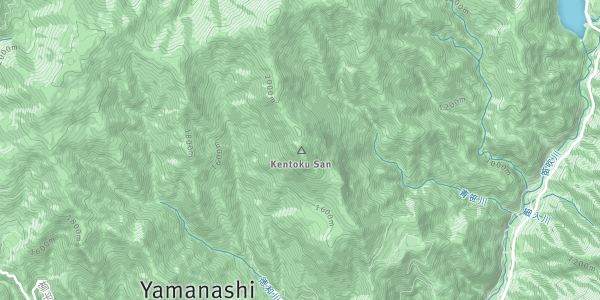
TWMC’s hike –乾徳山 (Kentoku-san), 2031 m July 14th (1-day main plan) and July 14th-15th 2018 (extended 2-day plan)
One of the Japan 200 Famous Mountains (日本二百名山, Nihon Nihyaku-meizan): http://yosniimura.net/yama/Japan200Mountains.html
Several reports about hikes at kentoku-san are available: https://climbjapan.blogspot.com/2014/07/running-and-scrambling-on-mt-kentoku.html http://ridgelineimages.com/hiking/mt-kentoku/
Main plan: 1-day hike, starting from Odaira (parking place, now a huge photovoltaic power station under construction), ascending the south face of Kentoku-san (chains) via the emergency hut (deer area), descending its North face (ladders) and completing the tour through the forest via the emergency hut again to Odaira.
2-day extended plan: Wakako, Floris, Thierry
Day 1: same route as the 1-day hike accompanying the 5 other hikers to the top of Kentoku-san. Ascent of its south face with ropes and chains. No need for either ropes or chains if you feel confident with trees and rocks. Descent of the north face with ladders and split in two group (5 hikers back to the parking for 1-day hike, pink route on the map; 3 hikers for the 2-day tour).
Hike on the woody ridge from Kentoku-san to Kurokane-yama (黒金山) with alternation of ascents / descents, gentle slope all way long (no water point). Top of Kurokane-yama (~2200 m) Not very spectacular (cloudy at that time) Possible to see 国師ケ岳 through the clouds. Descent to a cross-road called “大ダオ”. The map seems quite inaccurate for this part of the trail, with an alleged map time at 30 min while 1 hour is needed (in accordance with panels onsite). End of hike at ~6 pm.
大ダオ is a pass-like and flat area at ~2000 m clear of trees (forest fire? fungal disease?) making it ideal for bivouac. Full of flies though, a little camp fire helps keeping them away (dead trees around to feed the fire). Many deer walking around at night (unseen, only heard from tents).
大ダオ also offers a nice view on Kentoku-san and potentially Fuji-san in clear weather (the summit was barely visible in the morning) with an unobstructed view southward. Pretty bad choice for sunrise and/or sunset though with two peaks eastwards and westwards. Water point ~20 min downhill, steep trail.
Day 2: Descent from大ダオ (start at ~ 7 am) to the valley following several streams merging into one main river 徳和川 (dashed trail on the map, trail is indicated with pink ribbons). 徳和渓谷: beautiful ~1 km long loop trail along two rivers with several waterfalls – not indicated on the map. Fresh water seems to be totally drinkable (as for me, no problem so far in spite of drinking ~2L of it at different spots from spring to main river).
Multitude of dams on the way down getting closer to三富徳和 village, offering as many pools and potential campsites. Ascent of Kentoku-san once more via another route (乾徳山登山口) to reach the emergency hut (cf. 1-day report, Nobu-san) at ~ 1 pm.
At least 3 “official” water points on the way up (Ļ last one near the hut). Long lunch break and nap time near the hut, arriving at the parking lot at ~4 pm... right before a thunderstorm ! Onsen, dinner and back to Tsukuba (~ 9:30 pm)
Organiser

Co-organiser

Location