Sunday July 21, 2019
Details
The Nikko-Shirane hike is postponed!
Given the weather and the route, I deemed that we should cancel this time.
I would be grateful if you understand this decision.
I will re-organize it!
As of July 14th, all people signed up can go!
Anja
Asam
Sarah
Kotaro and Nozomi (5-passenger car)
Alex and Julia
Eunsam and Thierry (car)
I am waiting for more participants, although we need more cars.
If you are interested in, please let me know.
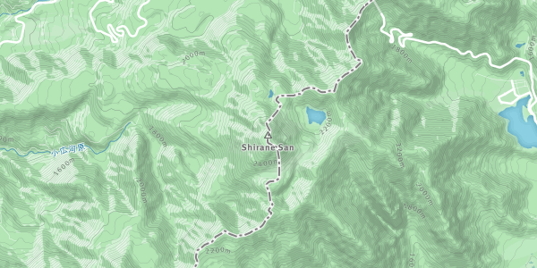
The destination is Mt. Nikko-Shirane which is the first mountain for TWMC.
This mountain is located in Nikko and have an altitude of 2,578 m.
On our route, there is two beautiful ponds.
Meeting time and place
5 A.M., at Tsukuba station car parking lot.
If this schedule is not fine with you (e.g. train schedule issue), please let me know.
Difficulty level: 3 out of 5.
Route
Suganuma gate (1735 m) - (2h) - Amidagaike pond - (1h) - summit (2578 m) - (1.5h) - Goshikinuma pond - (1.5h) - Suganuma gate
After climbing up to the summit, it takes 2h on foot for the ropeway summit station (2000 m).
You can download a route map for more details.
https://drive.google.com/file/d/1mZ_1Lr5inzMRAWLU6C0DXxLFIfdWSS8V/view?usp=sharing
If you want, you can take the ropeway for going down after the summit or Goshiki pond.
It costs 1100 yen, but you can shorten the walking route.
Please let me know if you want to take it.
What to bring
Hiking shoes
Rain gear
Lunch and snacks
Water, drinks
Onsen stuff
Backpack
Expected Costs:
Car and highway transportation : 5480 yen for highway toll per a car with ETC and gas for 350km
Parking lot : 1000 yen per car
Food (Up to you)
Onsen : 1000 yen?
Club fee : 300 yen
Insurance
Organiser

Location