Friday August 11, 2017
Details
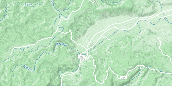
This is the final announcement for Shirakami August 11-15th
We leave tomorrow morning form Tsukuba Station (short time parking) at 4:00 am. Please be on time (set two alarm clocks if you are worried to wake up).
This year`s plan is to drive up to Shirakami Sanchi by rental car, so all 7 + luggage fit in one car (Toyoto HiAce).
Day 1: Hike up Ookawa, make base camp on river side
Day 2: Explore Shirakami forest by following up Ookawa river to deep gorge and waterfall, explore side routes if we find them, back to base camp
Day 3: Out Ookawa, drive (1.30h) to Shirakami Campsite, hike to BlackBearWaterfall, take Onsen at Kuma No Yu (Bear onsen)
Day 4: drive (1.30h) to Ten Lakes, Hike up Shirakami dake, stay at emergency hut
Day 5: watch sun rise, down from Shirakami dake, Furoufushi Onsen (No old age no dying Onsen) overlooking Japan Sea, drive back to Tsukuba
The details and packing are already discussed with the participants.
Weather forecast is cloudy or sunny, but rain on day 2. No need to worry, we will get wet on day two anyway.
This is the second announcement of this year`s Shirakami hike/sawanobori. Below you also find my report of our five day trip to explore a new route, or better to say just some highlights (pictures are here:
https://www.dropbox.com/sh/hfuj525905owq82/AABue864pXObP-u5xPdVZLVea?dl=0 ).
The bad news is, that for the official hike we will not be able to go the explored route for the following reasons:
1) crossing the mountains from one valley to the other is really difficult and dangerous, and
2) the Shirakami Line road is partially blocked, which makes very long approach walks on the forest road necessary to reach both Akaishigawa or Oirasegawa; such beautiful rivers, but getting there is hours and hours of walk on forest road.
So, as a rough idea I am proposing the following plan for this year:
Day 1: Leave Tsukuba 3 am by car, Hike up Oo-gawa (I explored alone last year), make base camp
Day 2: Enter core zone on a one day trip through deep gorge and possibly up to waterfall (leave luggage at base camp)
Day 3: Back out Oo-gawa, move by car to Japanese Sea side (3 hours drive), camp
Day 4: Climb Shirakami-dake (1232 m) on regular hiking trail
Day 5: Ocean, onsen, drive back (during day time, arrive late evening/night)
Difficulty level is downgraded to 3 out of 5 (but in case of rain and high water 4/5 and participants need to be able to swim, just in case). The plan mainly depends on the means of transportation (car or night bus), but also on participant’s opinion. I have made a reservation for night bus (which I can still cancel without charge),
but already for O-bon week only normal 4 seat row, small space, hard to sit and even harder to sleep for tall people type of night bus was available. It would be better to go by car! Maximum number of participants depends on car seats. Max reservation for night bus I made is 8. But flat camping space in the forest is very limited so that I might have to set the maximum number lower depending on these considerations.
Participants (some not everybody 100% decided yet):
Me
Kyoko
Thierry
Sam
Ryoko
Floris
Richard
Can we have an additional TWMC get-together on Wednesday, July 26 where all of participants and interested people can come to decide the plan and talk about Shirakami? Let me know if you can make it. I will ask Oto-san if we can meet from 8 pm at Hot Staff. I will not be in Tsukuba for the next monthly TWMC get-together on Aug. 2.
---- Report of exploring route Akaishigawa to Oirasegawa. This was not an official TWMC hike. -----
-
Night bus (3 seat row from Oomiya to Hirosaki), Bus to Tsugaru Toge on Shirakami line
-
Approach on forest road to Akaishigawa Dam
-
Second night strong rain, continues on third day high water in rivers and streams
-
Steep slopes: From Akaishigawa go upstream Takigawa (Waterfall river), search for bypass around waterfalls which are not possible to climb directly, meaning climbing high up the side of the valley holding on to branches, and abseiling on side above waterfall. On one traverse on the slope Thierry slipped and was sliding down 5 meters.
Luckily he found hold there and stopped his further involuntary decent. In one nice open part of the valley I spotted an Aomori Mantema flower (Silene aomorensis) which I recognized from an information panel. This flower was first found in Aomori prefecture.
Only that time I took out my camera even in the rain to take a picture. -
Crossing mountain ridge between Takigawa and Oirasegawa: Finding the right valley by map and compass we climbed all the way up to the ridge. Finding our orientation there was difficult because of about 50 m visibility of the surrounding topography in the rain. Going along the ridge a bit we decided on a favorable decent route down the
opposite side of the ridge. Using rope only once and going further down a small stream we reached a very nice valley quickly. Really happy about our successful crossing of the ridge we were awakened by a strange feeling of familiarity with this valley. “No… What?” “This cannot be!” “We have been here!!!” “How is that possible? We went down the opposite side!” And there it was right beside me: Silene aomorensis. We did end up in the same valley some distance lower. This took some time to figure out. Looking closely at the map, the ridge splits and one nose goes down into the same valley. We must have taken that small turn on the ridge, so that climbing down the opposite side actually does bring us back to the same valley. So we give it one more try, climbing up again the same way we just came down and following the ridge carefully. Double checking compass and map and comparing it to the 50 m visible surrounding topography. Making our way down, the valley and side valley does correspond to our map and we finally confirmed our successful mountain ridge crossing. -
Into the water: Going downstream Oirase-gawa we encounter several gorges and deep ponds. Climbing around them and abseiling takes lot of time, so that at some point we decided just to jump in and swim with our full back packs. In preparation, we had already packed everything water tight. Great fun, and much faster!
-
Oirase Dam “official bypass”: Finally reaching Oirase Dam we look for an official route around the dam which some internet report and one Shirakami book was mentioning. It is supposed to be on the right side, but all there is, is a steep rock face with no way up. Then I spot a tunnel entrance! So it seems we were looking for the wrong thing. It is not a way over the rock but through it. Putting on our headlights we head into the tunnel. In the beginning waking with head down was still possible, but the height of the tunnel kept decreasing steadily. Lowering the back pack straps to not stretch the ceiling first. Then walking crouched and carrying the backpack with the straps down in our pits of our elbows. Walking like this takes a lot of muscle. Markings on the tunnel wall tell us that it is still 300
meters to the other side. I found this situation still very interesting and asked Thierry that we turn off our lights and be completely quiet for two minutes: absolute silence and darkness – funny feeling (for me, Thierry said straight that he does not like being underground like this – understandable). We continue, the height of the tunnel keeps decreasing. “50m” mark – we are almost there. And there we were, in front of metal bars and a planked up tunnel exit
with just a little day light coming in. Back out we go, now dragging our back packs behind and just getting out of the tunnel as fast as possible. This might have been an official bypass …years ago. And who does that to close the exit but keep the entrance open? On water proof paper I wrote in English and Japanese that the opposite side is closed
and left it at the entrance. Our mind was now set on just abseiling the dam, which was not such a big dam. Before that I gave it one more try to find a route around, and on the left side I found it. Climbing out, we now reached back to the forest road. -
Out of the bushes: From Oirase Dam we reach the Shirakami Line which is our way out of the forest. We walk and talk. Thierry is still wearing his climbing harness on which some karabiners make some bear bell like sound. No extra bear bells needed. All of the sudden right next to us on the right side of the forest road the bushes move and we
hear some kind of growling sound. Through the leaves I see black fur: “ A BEAR! “ Facing into the direction of the bear, we move fast past and on the road to get away. (You should not turn your back to bears and run, because they react to this kind of fleeing.) The big bear does not come out of the bush, but now two baby bears climb the trunk of the tree to look at us. So cute! (But understandably no time for picture in such situation.) -
All the way to the coast: The Shirakami Line from there is still more than 20 km to Iwasaki on the Japanese Sea coast. Our hope was to reach the top of the mountain pass in about 6 km and get into cell phone reception to call a taxi. No reception, and as we found later on the way, the Shirakami Line was closed from the point 12 km to the
coast anyways so that no taxi could have reached us. At about kilometer ten a construction worker drives by us and kindly gives us a ride. -
We take Onsen and enjoy the view of the ocean. Back to reach our night bus from Hirosaki turns out to be a challenge. Only one train, but too long transfer times to get back in time. Considering that staying in Hirosaki and booking a new night bus ticket would cost the same as a taxi ride, we decide on the 2h taxi ride. We go to a Aomori
style Izakaya quickly for 40min and catch our night bus on time.
What an adventure. Everything turned out well and safe. Thanks Thierry, it was an awesome trip with you. Deep gratefulness to Shirakami.
This is an early first announcement for the Shirakami hike this August. You should know early about it to have a chance to plan ahead for your O-bon vacation this year.
The Shirakami (White God) mountain range is one of the very rare place untouched by human activity. This virgin beech forest is designated a natural Unesco World Heritage and located in the north of Japan`s main
island stretching over Akita and Aomori prefecture.
We will be exploring the core zone of Shirakami sanchi, going mostly along creeks and rivers, but also navigating through some forest with map and compass. There are no marked trails in the core zone, and this hike includes some canyoning, or Sawa-nobori as the Japanese say. For this reason it is difficulty 5 out of 5. We will bring rope and harness to go up and down waterfalls (depends on this year`s route if or how many times to use rope, if you do not have any experience it is okay too and we practice one time before). We will camp in the forest and carry all our supplies (except water which you can drink directly from the clear streams; isn't that awesome). You will need Sawanobori shoes (https://store.shopping.yahoo.co.jp/shugakuso/k026.html) with felt sole to not slip in the rivers, and most of the regular outdoor gear (tent, cooking, sleeping bag). Some of the gear can be shared, which we organize in detail before.
Means of transportation is either night bus or car. In case we have enough drivers (two per car, to switch drivers since it is an 8 hour drive) we might go by car. The plan as for now is to leave 10th of August in the evening and come back on 15th (evening) or 16th August (morning or evening). I will figure out the coming back time depending on route, participants and transportation as soon as possible.
Estimated cost: roughly ~15.000 yen (depends on means of transportation and number of participants, note that you might need to buy some equipment like shoes for the hike)
If you are interested in this hike, let me know the following:
Name
Cell phone number
Car: yes/no, how many seats
Driver's license: yes/no
Prefer car or night bus:
Time you can participate: coming back 15th or 16th Aug.
Level of climbing, canyoning, or outdoor experience:
Here are a few impressions from last year`s trip:
http://pho.to/Akwf9
Thierry and me will go to Shirakami to explore the route this month. This year`s route will be completely different route from last year's.
Organiser
Report
This is the report of this year`s Shirakami hike.
Some impressions of the trip you can find here:
http://dayviews.com/matagi/2017/8/29/
Day 1:
4:00, Meeting at Tsukuba Center
We went by rental car (HiAce Toyota) so that all seven of us plus luggage and even a folding bicycle could fit into one car. This made the trip much more convenient and only slightly raised the cost compared to going in two private cars. Although leaving early, traffic was quite dense due to the start of O-bon holidays, slow especially around Sendai.
16:00, Arrive at Shirakami Sanchi, Aomori prefecture
We went for a brief visit to pay our respect to Shirakami at the Shrine at Niogataki waterfall (乳穂ヶ滝) which is right beside the road entering Shirakami Sanchi from Hirosaki. From there we headed on to Ookawa Forest Road. Due to the late arrival we decided to drive up this well-maintained forest road instead of walking as was the initial
plan. Parking the car at the end of the forest road, we descended to the Ookawa river. Hiking up the river we made camp at a nice and rather flat and wide river bank.
Day 2:
Leaving our stuff at the camp, we headed out with light luggage for this day trip up Ookawa to Yodome no Taki Waterfall. It was raining all day, a light rainy season kind of rain. Temperatures during daytime were warm enough to not get cold, but lower than expected for August. Going upstream Ookawa we pass the deep gorge Takaheguri
(タカヘグリ) which is also called the Gate without entrance (不入の門). We were
lucky that it let us in, with water up to the hips we passed this amazing section smoothly.
Arriving at the waterfall, there is a clear bypass (Makimichi, as the Matagi say) to climb up. We had rope and harness with us, so the way down was to abseil the waterfall. Our 40m rope was however too short for this waterfall, so that we had to set it a few meters down the side of the waterfall to where we could safely descent without rope (due to rain, no pictures of this action). Upstream the waterfall is where the actual core zone starts, the most highly protected area of Shirakami. An interesting feature is that the river goes underground for a section above the waterfall, probably due to an old land slide.
This might have been the reason why we witnessed a quite sudden water rise of about 10 cm in 10 minutes, even though the rain did not change and was steadily continuing all day.
On the way back, we could find a stone with petrified wood in the river bed. Returning to the camp still in the rain and now with dropping evening temperatures we all sat together underneath one tarp to quickly cook our dinner and go to sleep right after.
Day 3:
Getting up early, there was time to explore the forest more and search for mushrooms. Luckily the rain stopped, so we could pack up our tents dry. From here we changed location to drive to the Bear Onsen (熊の湯) at the north side of Shirakami sanchi. On the way we stop at a “Matagi Restaurant” at the food of Mt. Iwaki for lunch and bought supplies for evening BBQ at a supermarket. At the Bear Onsen we set up our tents at
the camp ground and took a bath in iron rich bear brown water. The husband of the old couple running the onsen is actually a Matagi, that is what the people living close to Shirakami and collecting edible wild plants, mushrooms, and hunting bear are called. Talking to a real Matagi was a truly moving and inspiring event.
What the old Matagi had to say (Or: Message from Matagi)
The Matagi was a really kind and humble old man. When I asked him: “what became your strongest memory inside the forests of Shirakami? Like for example finding a huge Maitake Mushroom, encountering a bear, or falling down a waterfall?” He plainly replied: “These things are all normal in the forest.” I myself was really excited to have the chance to ask for information about some old routes inside the core zone and wanted to compare maps with what I had explored and what his usually routes were. However he told me that there are no maps, the old routes are overgrown, and the old Matagi huts do not exist anymore.
From his experience of living in and with the forest he told me that he knows that there are Kami-sama in the forest. Actually, God (or lets say Shirakami-sama) is always watching – watching what he does and at the same time watching over him. That is why a Matagi cannot do anything bad or evil because Kami-sama is always watching. There is no such thing that a Matagi would kill the last bear or take too much from the forest. He also helped me to confirm the identification of the mushrooms I collected for dinner (Sangoharitake, Oniiguchitake, and Chichitake), plus telling me that two more I was unsure about were not edible. In this season there are many poisonous mushrooms, he said, and for Maitake, which I wanted to find, it was too early. I still have so much to learn. The Shirakami Forest is now a Natural Unesco World Cultural Heritage, to be precise, the core zone is. So hardly any people actually have ever visited this World Cultural Heritage. As part of the conservation, Unesco explicitly includes the Matagi culture. However, the politicians are of different opinion. The rules set by the government prevent Matagi from continuing their lifestyle. This Matagi himself wrote proposals to the government trying to convince them of the value of the culture and old wisdom. He even went personally to Tokyo to explain the situation. That time, in such spoken conversation the politicians shockingly revealed their true mind (since from a conversation no record remains). They were saying that Matagi culture is irrelevant to our times and it is already dead, dead like the culture of native Indians in America or Ainu in northern Japan. Surely the Matagis comment: “Politicians are no good” is understandable. Who could change their distorted mind about the larger workings of nature, the universe and of how humans fit in?
Returning to the camp site we had BBQ. Some Iwana, mushrooms, and Mizo with meat roasted on Hoo no ki leaves were special treats from the forest. Although we were the only people at the camp ground that evening (except for one camping car), we got many visitors attracted by the bright lights. All came in their most fancy dress: green silky,
pure white with shining red outline, or with eyes painted on their wings. It was an astonishing array of different moth species.
Day 4:
Packing up early we drove to the Japanese Sea side to climb Shirakami dake (1235m). First we deposited a folding bicycle at the end point of the hike and then drove to 12 lakes (十二湖) which was our starting point. Enjoying the colors of the Blue Pond 青池 (but not having any time for the other lakes) we started out hiking up the mountain.
Already lunch time and with 6.30 h map time ahead we tried to keep a good pace to reach the emergency hut at the peak before sunset, which we managed to do. Luckily we had the emergency hut all to ourselves.
For water supply a delicious spring was hidden about 5 minutes from the hut going through deep bamboo grass.
Day 5:
In the morning I got up early, ate breakfast and started to descend from Shirakami dake first to pick up the car from the starting point.
Descending in 1h45min (map time 4 h), YEAH! Getting on the folding bicycle for a 10 km ride with the last section 3 km uphill, PHU! I got the car and was back an hour before everybody came down the mountain.
We take Onsen at “No old age no dying Onsen” (不老不死温泉) right at the ocean with an amazing view. Enjoying lunch at a sea food restaurant, we were on our way back to Tsukuba. A long drive in rather dense traffic but all in all maybe the better option instead of driving through the night.
2:00 back in Tsukuba
Thanks to all of the participants. You were a great team.
Location